
จังหวัดอุตรดิตถ์ ตั้งอยู่ทางภาคเหนือตอนล่าง ได้ชื่อว่าเมืองแห่งพระแท่นศิลาอาสน์ ตำนานอันลึกลับ ของเมืองลับแล ดินแดนแห่งลางสาดหวานหอม และบ้านเกิดของพระยาพิชัยดาบหัก ขุนศึกคู่บารมีของสมเด็จพระเจ้าตากสินมหาราช
อุตรดิตถ์เป็นเมืองก่อนประวัติศาสตร์ มีหลักฐานการค้นพบโบราณวัตถุสมัยก่อนประวัติศาสตร์ ในสมัยอยุธยาและสมัยธนบุรี เมืองพิชัยและสวางคบุรีเป็นเมืองที่มีความสำคัญ ทางยุทธศาสตร์ เป็นเมืองหน้าด่านของกรุงศรีอยุธยา เดิมทีตัวเมืองอุตรดิตถ์เป็นเพียงตำบล ชื่อ "บางโพธิ์ท่าอิฐ" ขึ้นกับเมืองพิชัย แต่เพราะบางโพธิ์ท่าอิฐซึ่งอยู่ริมฝั่งขวาของแม่น้ำน่านมีความเจริญรวดเร็ว เพราะเป็นท่าเรือขนถ่ายสินค้า ดังนั้นในสมัยรัชกาลที่ 5 พระองค์จึงทรงพระกรุณาโปรดเกล้า ฯ ยกฐานะ ตำบลบางโพธิ์ท่าอิฐขึ้นเป็นเมือง "อุตรดิตถ์" ซึ่งมีความหมายว่าท่าน้ำแห่งทิศเหนือ แต่ยังคงขึ้นกับเมืองพิชัยอยู่ ต่อมาเมืองอุตรดิตถ์มีความเจริญขึ้นมากกว่าเมืองพิชัย เมืองอุตรดิตถ์จึงได้รับการยกฐานะขึ้นเป็นจังหวัด และเมืองพิชัยเลื่อนลงไปเป็นอำเภอหนึ่งขึ้นกับจังหวัดอุตรดิตถ์จนทุกวันนี้
อุตรดิตถ์เป็นเมืองก่อนประวัติศาสตร์ มีหลักฐานการค้นพบโบราณวัตถุสมัยก่อนประวัติศาสตร์ ในสมัยอยุธยาและสมัยธนบุรี เมืองพิชัยและสวางคบุรีเป็นเมืองที่มีความสำคัญ ทางยุทธศาสตร์ เป็นเมืองหน้าด่านของกรุงศรีอยุธยา เดิมทีตัวเมืองอุตรดิตถ์เป็นเพียงตำบล ชื่อ "บางโพธิ์ท่าอิฐ" ขึ้นกับเมืองพิชัย แต่เพราะบางโพธิ์ท่าอิฐซึ่งอยู่ริมฝั่งขวาของแม่น้ำน่านมีความเจริญรวดเร็ว เพราะเป็นท่าเรือขนถ่ายสินค้า ดังนั้นในสมัยรัชกาลที่ 5 พระองค์จึงทรงพระกรุณาโปรดเกล้า ฯ ยกฐานะ ตำบลบางโพธิ์ท่าอิฐขึ้นเป็นเมือง "อุตรดิตถ์" ซึ่งมีความหมายว่าท่าน้ำแห่งทิศเหนือ แต่ยังคงขึ้นกับเมืองพิชัยอยู่ ต่อมาเมืองอุตรดิตถ์มีความเจริญขึ้นมากกว่าเมืองพิชัย เมืองอุตรดิตถ์จึงได้รับการยกฐานะขึ้นเป็นจังหวัด และเมืองพิชัยเลื่อนลงไปเป็นอำเภอหนึ่งขึ้นกับจังหวัดอุตรดิตถ์จนทุกวันนี้
ประวัติ
ประวัติความเป็นมาต้นกำเนิดของจังหวัดอุตรดิตถ์ มีแหล่งกำเนิดมาจากท่าน้ำที่ สำคัญ 3 ท่า คือ ท่าเซา ท่าอิด และท่าโพธิ์ ซึ่งมีความสำคัญและเจริญรุ่ง เรืองมาแต่สมัยขอมปกครองท่าอิด ตั้งแต่ พ.ศ. 1400 คำว่า อุตรดิตถ์ เดิมเขียน เป็น อุตรดิษฐ์ (อุตร-เหนือ, ดิตถ์-ท่าน้ำ) เป็นคำที่ตั้งขึ้นในภายหลัง โดย พระบาทสมเด็จพระจอมเกล้าเจ้าอยู่หัวรัชกาลที่ 4 แห่งราชวงศ์จักรี พระราชทานนาม ไว้เมื่อ พ.ศ. 2395 แปลว่า ท่าเรือด้านทิศเหนือของสยามประเทศ
ท่าอิด คือ บริเวณท่าอิฐบนและท่าอิฐล่างปัจจุบัน
ท่าโพธิ์ คือ บริเวณวัดท่าถนน ตลาดบางโพ เนื่องจากมีต้นโพธิ์มาก มีคลองไหลผ่าน เรียกว่า คลองบางโพธิ์ (เพี้ยนมาเป็นบางโพ)
ท่าเซา คือ บริเวณตลาดท่าเสา (เซา เป็นภาษาเหนือ แปลว่า พักนอน)
ท่าอิด (อิด แปลว่า เหนื่อย) เนื่องจากการเดินทางมาค้าขายที่ท่าอิดทางเรือ และทางบกของจังหวัดภาคเหนือและภาคกลางสมัยโบราณ กว่าจะถึงก็เหนื่อย ท่าอิดเป็นท่าที่มีความเจริญทางการค้ามากกว่าทุกท่าในภาคเหนือ เป็นท่าจอดเรือ ค้าขายจากมณฑลภาคเหนือและภาคกลางรวมถึงเชียงตุง เชียงแสน หัวพันทั้งห้าทั้งหก สิบสองปันนา สิบสองจุไทย เดิมท่าอิดอยู่ในความปกครองของขอมตลอดจน ถึงสมัยสุโขทัย ขอมหมดอำนาจ ท่าอิดจึงเป็นเมืองท่าขึ้นอยู่กับเมืองทุ่งยั้ง อันเป็นเมืองหน้าด่านของสุโขทัย สมัยต่อมาแควน่านได้เปลี่ยนทางเดินทำให้หาดท่าอิดงอกออกไปทางตะวันออกมากทุก ๆ ปี ท่าอิดจึงเลื่อนตามลงไปเรื่อยๆ เรียกว่าหาดท่าอิดล่าง ท่าอิดเดิมเรียกว่าท่าอิดบน ท่าอิดล่างก็ยังคงเป็น ศูนย์การค้ามาตลอดจนถึงสมัยรัตนโกสินทร์
สภาพภูมิศาสตร์
จังหวัดอุตรดิตถ์ อยู่ใต้สุดของภาคเหนือ ทิศเหนือติดต่อกับจังหวัดแพร่ ทิศตะวันออกติดต่อกับสาธารณรัฐประชาธิปไตยประชาชนลาว มีเขตแนวพรมแดน 120 กิโลเมตร ทิศใต้ติดต่อกับจังหวัดพิษณุโลก ทิศตะวันตกติดต่อกับจังหวัดสุโขทัย มีพื้นที่ประมาณ 7,854 ตารางกิโลเมตร ภูมิประเทศส่วนใหญ่เป็นภูเขาและที่สูง ซึ่งอยู่ทางตอนเหนือและทางตะวันออกของจังหวัด เทือกเขาเหล่านี้ต่อเนื่องมาจากจังหวัดแพร่ และจังหวัดน่าน
หน่วยการปกครอง
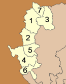
การปกครองแบ่งออกเป็น 9 อำเภอ 67 ตำบล 562 หมู่บ้าน
1. อำเภอเมืองอุตรดิตถ์
2. อำเภอตรอน
3. อำเภอท่าปลา
4. อำเภอน้ำปาด
5. อำเภอฟากท่า
6. อำเภอบ้านโคก
7. อำเภอพิชัย
8. อำเภอลับแล
9. อำเภอทองแสนขัน

จังหวัดอุตรดิตถ์ อยู่ใต้สุดของภาคเหนือ ทิศเหนือติดต่อกับจังหวัดแพร่ ทิศตะวันออกติดต่อกับสาธารณรัฐประชาธิปไตยประชาชนลาว มีเขตแนวพรมแดน 120 กิโลเมตร ทิศใต้ติดต่อกับจังหวัดพิษณุโลก ทิศตะวันตกติดต่อกับจังหวัดสุโขทัย มีพื้นที่ประมาณ 7,854 ตารางกิโลเมตร ภูมิประเทศส่วนใหญ่เป็นภูเขาและที่สูง ซึ่งอยู่ทางตอนเหนือและทางตะวันออกของจังหวัด เทือกเขาเหล่านี้ต่อเนื่องมาจากจังหวัดแพร่ และจังหวัดน่าน

หน่วยการปกครอง
การปกครองแบ่งออกเป็น 9 อำเภอ 67 ตำบล 562 หมู่บ้าน
1. อำเภอเมืองอุตรดิตถ์
2. อำเภอตรอน
3. อำเภอท่าปลา
4. อำเภอน้ำปาด
5. อำเภอฟากท่า
6. อำเภอบ้านโคก
7. อำเภอพิชัย
8. อำเภอลับแล
9. อำเภอทองแสนขัน

สัญลักษณ์ประจำจังหวัด
· คำขวัญประจำจังหวัด: เหล็กน้ำพี้ลือเลื่อง เมืองลางสาดหวาน บ้านพระยาพิชัยดาบหัก ถิ่นสักใหญ่ของโลก
· คำขวัญประจำจังหวัด: เหล็กน้ำพี้ลือเลื่อง เมืองลางสาดหวาน บ้านพระยาพิชัยดาบหัก ถิ่นสักใหญ่ของโลก
Uttaradit (Thai: อุตรดิตถ์) is one of the northern provinces (changwat) of Thailand. Neighboring provinces are (from south clockwise) Phitsanulok, Sukhothai, Phrae and Nan. To the east it borders Xaignabouli of Laos
History
The name Uttaradit means northern landing, as it was formerly a trade center on the Nan river.
In the Sukhothai era several city state (Mueang) controlled by the King in Sukhothai were located in the area of the modern province. Mueang Fang was located in modern day Mueang Uttaradit district, Mueng Thung Yang in Lablae, Mueang Ta Chuchok in Tron district.
Later in the Ayutthaya kingdom Mueang Phichai was one of the 16 main Mueang of the kingdom. During the reign of King Naresuan the ruler of Phichai together with the ruler of Sawankhalok revolted. After their revolt was suppressed by the King the population of both cities was forced to move to Phitsanulok.
During the war with the Burmese after the fall of Ayutthaya, Phichai was the site of several battles. The ruler of Phichai succeeded to fight back the Burmese and was awarded with the title Phraya Phichai Dabhak.
During the reign of King Rama III Mueang Phichai controlled several Mueang of northern Siam like Nan or Phrae, and even Luang Prabang and Vientiane. At the point where the Nan river became shallow a port was established. As this town grew in importance as an important trade point, in 1887 it was made a Mueang subordinate of Phichai. 1899 the center of Phichai was moved to this new location, which was renamed to Uttaradit in 1915.

Geography
explanation of The largest Teak tree
The province is located in the valley of the Nan River. About 45 kilometers north of the city Uttaradit is the Queen Sirikit Dam, created a 250 km² artificial lake from the Nan.
Most of the province was once covered with teak forests, then the major product of Uttaradit. The largest Teak tree in the world is found at the Ton Sak Yai Park. The 1500 year old tree measures 9.87 m in circumference and 37 m in height - originally it was 48.5 m high, but it was damaged in a storm.
Three National Parks are located in the province—Klong Tron, Lam Nam Nan and Phu Soi Dao.
Administrative divisions
The province is subdivided in 9 districts (Amphoe). These are further subdivided into 67 communes (tambon) and 562 villages (muban).
1. Mueang Uttaradit
2. Tron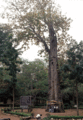
3. Tha Pla
4. Nam Pat
5. Fak Tha
6. Ban Khok
7. Phichai
8. Laplae
9. Thong Saen Khan
explanation of The largest Teak tree
The province is located in the valley of the Nan River. About 45 kilometers north of the city Uttaradit is the Queen Sirikit Dam, created a 250 km² artificial lake from the Nan.
Most of the province was once covered with teak forests, then the major product of Uttaradit. The largest Teak tree in the world is found at the Ton Sak Yai Park. The 1500 year old tree measures 9.87 m in circumference and 37 m in height - originally it was 48.5 m high, but it was damaged in a storm.
Three National Parks are located in the province—Klong Tron, Lam Nam Nan and Phu Soi Dao.
Administrative divisions
The province is subdivided in 9 districts (Amphoe). These are further subdivided into 67 communes (tambon) and 562 villages (muban).
1. Mueang Uttaradit
2. Tron

3. Tha Pla
4. Nam Pat
5. Fak Tha
6. Ban Khok
7. Phichai
8. Laplae
9. Thong Saen Khan
Symbols 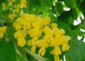
The provincial seal shows the mondop at the temple Wat Phra Thaen Sila At, in Baan Phra Thaen in the Laplae district. The main item of worship in the temple is a laterite block, which is believed to have been used by Buddha to seek enlightenment. The mondhop is built upon this block.
The seal was first designed in 1940, later a garuda as the symbol of Thailand and the name of the province were added.
The provincial tree is the Teak (Tectona grandis).

ไม่มีความคิดเห็น:
แสดงความคิดเห็น